The Salty Mariner

Home

All Posts

Latest News

Maritime Companies

Training Centers

Contact

Advanced Navigation Systems: GPS, AIS, and Next-Gen Maritime Navigation

From Stars to Satellites: How Navigation Has Changed

Picture this: You're standing on the bridge of a modern cargo ship, and instead of the traditional compass and paper charts, you're looking at a wall of digital displays showing your exact position, the locations of other ships, weather patterns, and the optimal route to your destination. All of this information is updated in real-time, and the system can even suggest course changes to avoid traffic or bad weather.
This is the reality of modern maritime navigation. We've come a long way from the days when sailors relied on the stars, compasses, and dead reckoning to find their way across the oceans. Today's ships use sophisticated satellite systems, advanced radar, and artificial intelligence to navigate with incredible precision.
As a marine engineer who's been watching this technology evolve, I can tell you it's pretty amazing. The navigation systems on modern ships are more powerful than the computers that put men on the moon. They can track dozens of other vessels simultaneously, predict weather patterns, and even suggest the most fuel-efficient routes.
In this article, I'll walk you through the advanced navigation systems that are revolutionizing maritime operations. We'll cover everything from GPS and AIS to next-generation navigation technology, and I'll explain what this means for the future of shipping. For more context on maritime technology trends, check out our main article on the future of maritime technology.

GPS: The Foundation of Modern Navigation

Let's start with GPS - the Global Positioning System. This is probably the most important navigation technology ever developed, and it's completely transformed how ships navigate the oceans.
GPS works by using a network of satellites orbiting the Earth. These satellites constantly broadcast their position and the exact time. Your GPS receiver picks up signals from multiple satellites and uses the time differences to calculate your exact position on Earth.
The accuracy is incredible. Modern GPS systems can determine your position to within a few meters, even in the middle of the ocean. This is a huge improvement over traditional navigation methods, which could be off by miles.
But GPS isn't just about knowing where you are. Modern systems can also:
  • Calculate Speed and Course: By tracking your position over time, GPS can determine how fast you're moving and in what direction. This is essential for navigation and collision avoidance.
  • Provide Time Synchronization: GPS provides incredibly accurate time signals, which are used by many ship systems for coordination and data logging.
  • Enable Precise Docking: Modern GPS systems can guide ships to within inches of their intended position, making docking much safer and more efficient.
  • Support Autonomous Navigation: GPS is essential for autonomous ships, providing the precise positioning data needed for unmanned navigation.

AIS: The Eyes of the Maritime World

AIS - the Automatic Identification System - is another game-changing technology that's revolutionized maritime navigation. It's basically a system that allows ships to "see" each other and share information about their position, speed, and course.
Here's how it works: every ship equipped with AIS continuously broadcasts information about itself, including its name, position, speed, course, and destination. Other ships in the area receive this information and display it on their navigation systems.
The benefits are huge:
  • Collision Avoidance: Ships can see other vessels even when they're not visible on radar, making navigation much safer, especially in busy shipping lanes.
  • Traffic Management: Port authorities and coast guards can monitor ship traffic in real-time, helping to prevent congestion and accidents.
  • Search and Rescue: If a ship is in distress, AIS can help rescue services locate it quickly and accurately.
  • Environmental Monitoring: AIS data can be used to track ship movements and monitor compliance with environmental regulations.
AIS is now mandatory on most commercial ships, and it's become an essential tool for maritime safety and efficiency.

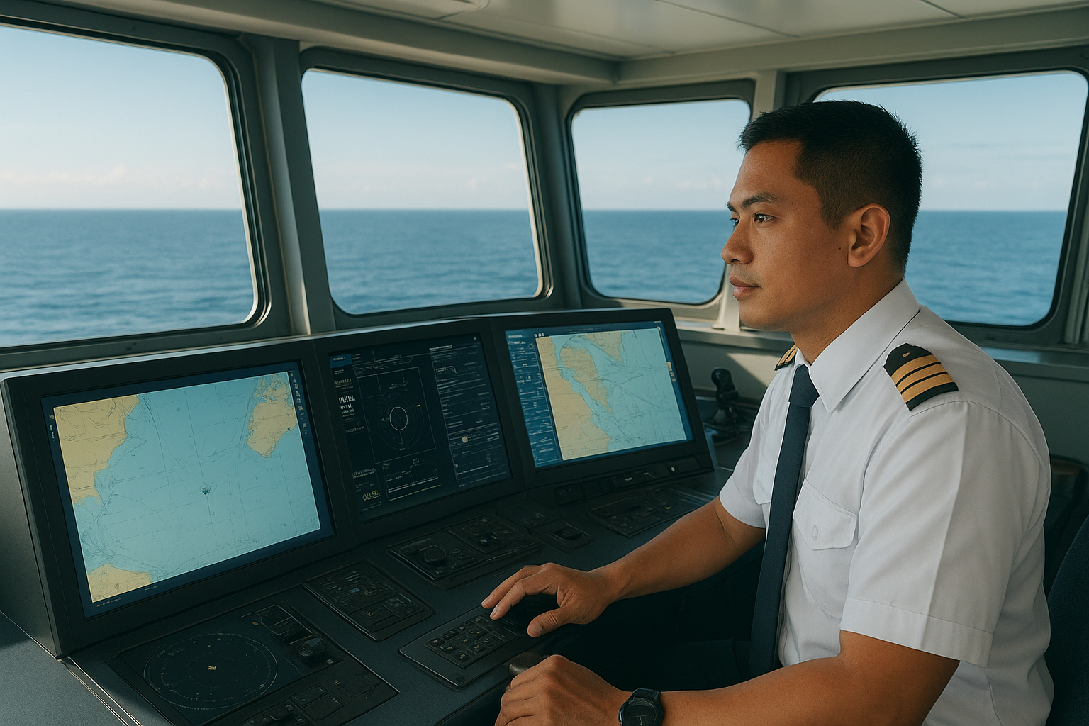
Electronic Chart Display and Information Systems (ECDIS)

ECDIS is basically a digital version of traditional paper charts, but it's so much more than that. It's a sophisticated navigation system that combines electronic charts with GPS, radar, and other sensor data to provide a comprehensive view of the ship's situation.
Here's what makes ECDIS so powerful:
  • Real-Time Updates: Electronic charts can be updated instantly with new information about hazards, weather, or other changes. This is much faster than waiting for new paper charts to be printed and distributed.
  • Integration with Other Systems: ECDIS can display information from GPS, radar, AIS, and other systems all on one screen, giving navigators a complete picture of their situation.
  • Automatic Route Planning: The system can automatically plan routes that avoid hazards and optimize for fuel efficiency or time.
  • Collision Avoidance: ECDIS can display other ships from AIS data and calculate collision risks, alerting navigators to potential problems.
ECDIS is now mandatory on most commercial ships, and it's become the standard for maritime navigation.

Radar: Still Essential After All These Years

You might think that with GPS and AIS, radar would be obsolete. But that's not the case. Radar is still one of the most important navigation tools on ships, and it's getting more sophisticated all the time.
Modern radar systems can detect objects that don't transmit AIS signals, like small boats, debris, or even whales. They can also work in conditions where GPS might be unreliable, like during solar storms or in areas with heavy interference.
The latest radar systems include:
  • Automatic Target Tracking: The system can automatically track multiple targets and predict their movements, making collision avoidance much easier.
  • Weather Detection: Modern radar can detect weather patterns and help ships avoid storms or other hazardous conditions.
  • Integration with Other Systems: Radar data is integrated with GPS, AIS, and other systems to provide a complete picture of the ship's environment.
  • Advanced Signal Processing: New radar systems use advanced signal processing to filter out noise and improve target detection in difficult conditions.

Next-Generation Navigation Technology

The future of maritime navigation is even more exciting. New technologies are being developed that will make navigation even more precise, efficient, and safe.
Artificial Intelligence and Machine Learning: AI systems can analyze vast amounts of data to predict weather patterns, optimize routes, and even suggest course changes to avoid problems. They can learn from every voyage and get better at navigation over time.
Augmented Reality: AR systems can overlay navigation information directly onto the view from the bridge, making it easier for navigators to understand their situation and make decisions.
Quantum Navigation: Quantum sensors are being developed that could provide navigation data even when GPS is unavailable. These systems use quantum physics to measure the Earth's magnetic field and other natural phenomena.
Satellite Constellations: New satellite constellations are being launched that will provide even more accurate positioning data and better coverage in remote areas.

Integration and Automation

One of the biggest trends in maritime navigation is the integration of different systems and the automation of navigation tasks. Modern ships can automatically adjust their course to avoid other vessels, optimize their route for fuel efficiency, and even dock themselves.
Integrated Bridge Systems: These systems combine all navigation equipment into a single, unified interface. Navigators can control everything from one place, making operations more efficient and reducing the risk of errors.
Automatic Route Optimization: Ships can automatically adjust their route based on weather conditions, traffic, and other factors. This can save fuel and time while improving safety.
Collision Avoidance Systems: Advanced systems can automatically detect collision risks and suggest or even execute evasive maneuvers. This is especially important for autonomous ships.
Predictive Maintenance: Navigation systems can monitor their own health and predict when maintenance is needed, reducing the risk of equipment failures at sea.

Challenges and Limitations

Despite all these advances, maritime navigation still faces some challenges. It's important to understand these limitations to use the technology effectively.
GPS Vulnerabilities: GPS signals can be jammed or spoofed, and they're vulnerable to solar storms and other interference. Ships need backup navigation systems for when GPS is unavailable.
Cybersecurity Risks: As navigation systems become more connected, they become more vulnerable to cyber attacks. This is a growing concern that needs to be addressed.
Human Factors: Even with advanced technology, human error is still a major cause of maritime accidents. Crew members need proper training to use these systems effectively.
Cost and Complexity: Advanced navigation systems are expensive and complex. Smaller ships and companies may struggle to afford the latest technology.

The Future of Maritime Navigation

So what's next? The future of maritime navigation is going to be even more exciting, with new technologies that will make shipping safer, more efficient, and more sustainable.
Fully Autonomous Navigation: We're moving toward ships that can navigate completely autonomously, using AI and advanced sensors to make all navigation decisions without human intervention.
Real-Time Weather Integration: Navigation systems will be able to access real-time weather data and automatically adjust routes to avoid storms and other hazardous conditions.
Global Traffic Management: A global system for managing ship traffic will help prevent congestion and accidents, especially in busy shipping lanes.
Environmental Optimization: Navigation systems will be able to optimize routes for environmental impact, helping ships reduce their carbon footprint and comply with environmental regulations.

What This Means for Maritime Careers

If you're thinking about a career in maritime, advanced navigation systems are creating lots of new opportunities. The industry needs people who understand both traditional navigation and new technology.
Navigation System Specialists: These professionals specialize in installing, maintaining, and troubleshooting advanced navigation systems. They need to understand both the technology and maritime operations.
Data Analysts: With all the data that navigation systems generate, companies need analysts who can interpret this information and provide insights for optimization.
Software Developers: The maritime industry needs developers who can create software for navigation systems, including AI and machine learning applications.
Traditional Skills Still Matter: Even with advanced technology, ships still need traditional navigators who understand the fundamentals of maritime navigation. The skills are evolving, but the basics remain the same.

Frequently Asked Questions

How accurate are modern GPS systems for maritime navigation?

Modern GPS systems can determine a ship's position to within a few meters, even in the middle of the ocean. This is much more accurate than traditional navigation methods and is sufficient for most maritime operations.

What happens if GPS fails on a ship?

Ships have backup navigation systems including radar, AIS, and traditional methods like dead reckoning. Modern ships are designed to continue operating safely even if GPS is unavailable.

Are autonomous ships really possible with current navigation technology?

Yes, autonomous ships are already being tested and are expected to become more common in the coming years. Current navigation technology is advanced enough to support autonomous operations, though there are still regulatory and safety challenges to overcome.

Conclusion

Advanced navigation systems have completely transformed maritime operations, making shipping safer, more efficient, and more precise than ever before. From GPS and AIS to next-generation AI-powered systems, the technology continues to evolve at a rapid pace.
As a marine engineer, I'm excited about what this means for the industry. We're going to see safer ships, more efficient operations, and new opportunities for people with the right skills. The technology is here, it's working, and it's getting better every day.
For more insights into maritime technology and careers, explore our articles on the future of maritime technology, maritime cybersecurity, and autonomous ships.
The age of advanced maritime navigation is here. The question isn't whether it's going to happen - it's how quickly we can make it happen. And based on what I'm seeing, it's going to be faster than anyone expected.

© 2025 The Salty Mariner. All rights reserved.

Privacy PolicyAccessibilityDisclaimer